Iran's Location and Size.
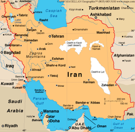
Iran is located in the Middle East, bordering the Gulf of Oman, the Persian Gulf, and the Caspian Sea. Iran is between Iraq and Pakistan. Iran's geographic coordinates are 32 00 North, 53 00 East. Iran's total area is 1,648,195 sq km which is about 2.5 times larger than Texas. It ranks 19th in total area compared to other countries. Iran borders Afghanistan, Armenia, Azerbaijan, Iraq, Pakistan, Turkey, and Turkmenistan. Iran's capital (most populated city) is located on the map on the left.
Terrain, Elevation, and Land Use.

Iran has a mostly arid or semiarid climate, but has a subtropical climate along the Caspian coast. Iran has many different terrains. Iran has rugged, mountainous rims; high, central basins with deserts, mountains; and small, discontinuous plains along both coasts. About 30% of Iran's land is used as agricultural land, 7% of Iran's land are forests, and the other 63% of Iran's land is used for other purposes. The graph on the left shows the major crops and where they are located.
Source: CIA Factbook.
URL: https://www.cia.gov/library/publications/the-world-factbook/geos/ir.html
URL: https://www.cia.gov/library/publications/the-world-factbook/geos/ir.html
